Although Alabama may not be at the top of many travel bucket lists, like the South in general, there are many things to do and see in the Heart of Dixie. Vera Marie Badertscher from A Traveler’s Library shares her experience exploring this little-known area on a northeast Alabama itinerary for boomer roadtrippers. She calls it the three-state byway trip.
Why don’t more people know northeast Alabama? I tried crowdsourcing. “What can I see on my road trip through northeast Alabama?” Ideas came in for Dismals Canyon in northwest Alabama, for the Civil Rights Trail, for plantations, for the fine dining in Birmingham—but nothing for northeast Alabama.
Northeast Alabama road trip itinerary

I turned to the Internet for state and national scenic byways, and looked at state parks. There I discovered some well-kept secrets.
For our drive from the Atlanta airport to Chattanooga, Tennessee, we detoured off freeways by combining two byways, starting in the little town of Heflin, AL just north of Interstate 20. (I-20 sails westward, and is easily reached from the airport by taking the Thornton Camp Creek Parkway.)
Appalachian Highlands Byway
Once we reached Heflin (exit 199) we joined the Appalachian Highlands Byway, running north on Alabama State Route 9. We paused for lunch and a break from rain showers at a regional, privately owned fast food restaurant chain, Jack’s, home of tall, fluffy biscuits, fried chicken and other yummy Southern cooking treats. It was Sunday and the church ladies stopped in for lunch with dripping umbrellas protecting their brightly flowered dresses.
The Appalachian Highlands Byway skirts national and state forests, crosses farmland once occupied by Creek Indians, and ducks through some small towns that could pass for Mayberry. Bike trails, forest hiking and canoe trails tempted us along the route, but today we were just passing through.
We did take a break to pay our respects at the site of the Goshen United Methodist Church Memorial. On Palm Sunday, 1997, while they were worshipping, a tornado destroyed the church and killed twenty people. The site is quiet and sad.
The Lookout Mountain Parkway
As we neared the town of Fort Payne, we joined The Lookout Mountain Parkway to explore the first of three stunning scenic destinations along the byway.
Ft. Payne is important to Cherokee history. It was a historic settlement, and became the starting point of the Cherokee Trail of Tears. Country Western music fans know Ft. Payne as the home of the group, Alabama, and flock to the Alabama Museum.
Directions: At Centre go west on U.S. 411 to Leesburg, then north on Alabama 273. At the town of Blanche, go west on Alabama 35.
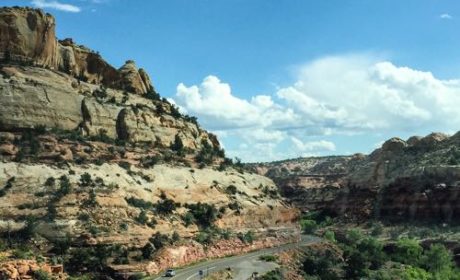
Little River Canyon
Little River Canyon National Preserve turned out to be our first scenic surprise.
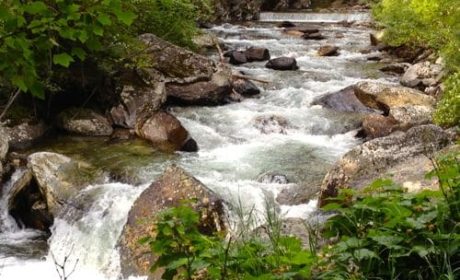
The Little River Runs along the mountain top and has cut a twelve-mile, 500-600 foot gorge, protected by the National Preserve. Since we live in the Grand Canyon State, we are a little hard to impress when it comes to gorges, but this is one of the largest canyon systems in the East and a real contrast to the usual southern vistas of flat cotton fields or sprawling cities like Huntsville or Atlanta.
After watching hawks circle over the canyon and pondering all the hikes we could take and waterfalls we could sample if we stayed here a bit, we headed for our home for the night.
Desoto State Park

DeSoto State Park, situated in the northern end of the Little River National Preserve intrigued me with historic events with a 1930s cabin; a 1920s dam, and quite a few telltale signs of the Spanish Explorers from the 1500s.

We settled into our spacious housekeeping cabin built in the 1930’s by the CCC (Civilian Conservation Corps). A small museum displays mementos of the CCC role in creating DeSoto State Park.
Although the cabin we rented is called primitive, it is anything but. It has been modernized with electricity, A/C, heat, and even WiFi.
It would have been easy to stay here for a week or more. We had dinner at the 1930’s era lodge, where the ambiance definitely outshines the food, and back at our cabin sat on the rocking chairs on the screened porch, listening to bugs and birds say goodnight.

The next morning we headed to DeSoto Falls where a party of Ferdinand DeSoto’s hearty Spaniard explorers camped in 1540 as they explored the southeastern part of the continent. My imagination ran wild conjuring up the camp of the Spanish explorers so far from their home.
In the 1920’s—before the park existed—an entrepreneur built a small dam above the falls and planned a resort development, including golf courses. Fortunately for nature lovers, the Great Depression doomed his grandiose schemes. But the dam, which still stands, provided electricity for surrounding areas until the Tennessee Valley Authority came along in the mid 1930s.
Mentone, old town Appalachia
The drive along the Brow, as locals call the western edge of the mountain goes through thick forests that for the most part obscure the views from the mountain, until you reach Mentone. The tiny town has a few blocks of Appalachian old town with quaint shops and restaurants.
Fortunately for my wallet, the attractive craft shops were closed when we arrived. Follow the signs to Brow Park for picnic tables with a view that goes on forever.
Cloudland Canyon

From Mentone, we followed Alabama 117 across the Georgia line where it becomes Georgia 48. There we ran into a state park that lives up to its ethereal name of Cloudland Canyon State Park.

I might have planned glamping in a yurt, and taken time to explore a cave or tested my endurance on a waterfall trail that includes 1200 stair steps. But I took the easy route.
Luckily, the very best views from the park are right at the main picnic grounds along the Rim Walk. After a picnic lunch, we tore ourselves away from Cloudland and got back on the Parkway, leading to Chattanooga and the not-so-secret tourist attractions of Tennessee’s end of Lookout Mountain.
But that’s a drive for another day.
Northeast Alabama road trip tips
- De Soto State Park’s website describes their cabins, and you can make reservations online or by phone. Ask about senior rates. There’s a minimum stay, but they waived it for us.
- I was disappointed in the AAA maps which no longer show rest stops and miss state and county parks. Try mailing the visitors bureau of the states you’ll visit for a better map, or supplement a AAA map by using the routes as described on state and national byway pages.
- Park fees vary. DeSoto: Entrance fee. Little River Canyon: no fees. Cloud Canyon: Parking Fee at picnic ground.
- Stock up on food and gas before you hit Lookout Mountain Parkway. There are few stores and restaurants. For our picnic at Cloudland, we picked up delicious sandwiches at a filling station/general store with a restaurant in the back located a couple miles west of the entrance.
- Besides the website links in this article, check out the attractive magazine, Lookout Mountain Alabama for some great tips in exploring this area.
Photos via Vera Marie Badertscher, or as noted, by Kenneth R. Badertscher.
Did you know that we publish a weekly broadcast with the latest articles from My Itchy Travel Feet, timely trip inspiration and travel deals? Subscribe by clicking here.