Over the last few months, NSW Australia resident and guest contributor Leslie Connor from Empty Nesters Travel Insights has been sharing insider tips for planning various Australian road trips. Today, she’s taking us on an exciting baby boomer road trip from charming Adelaide to beautiful Melbourne.
A road trip from Adelaide to Melbourne should only take about eight hours, if you choose to drive straight through without stopping. However, this route goes through a number of charming areas that really deserve exploring. Here is a breakdown of all the wonderful things to do and see while roadtripping from Adelaide to Melbourne:
Table of Contents
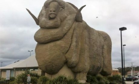
First Stop: Mount Gambier
Adelaide to Mt Gambier: 434 km, around 5 hours
Our tour around the South Australian Limestone Coast brought us to the city of Mount Gambier. Midway between Adelaide and Melbourne, the city is famous for its crater lakes. The Blue Lake in Mount Gambier is the city’s most famous attraction, but the area also boasts a number of historic buildings and unique gardens, caves and, of course, the lakes. With only the day to explore, we chose to visit a few of Mount Gambier’s natural wonders.

The Blue Lake in Mount Gambier inhabits one of the extinct volcanic craters. During the summer months the change in water temperature transforms the color of the lake to a vibrant cobalt blue. There are a number of conflicting theories as to what causes this phenomenon. We were fortunate to visit on a day when the lake was certainly living up to its vivid reputation. During the colder months, the water turns to a steely grey and would be fairly unremarkable.
As this is also the region’s water supply, the Blue Lake is strictly “view only” with water sports of any kind strictly forbidden.
It is possible to take a 3.6 kilometer walk past a number of viewing platforms around the lake. However as we were visiting on a searingly hot 38°C degree day, we chose to pass on that opportunity. Instead we took advantage of the viewing platforms closest to the visitor’s center.
Mount Gambier’s Valley Lake
The Blue Lake is only one of a number of crater lakes surrounding Mount Gambier. The nearby Valley Lake also offers scenic walks, swimming and picnic areas and a nature conservation area on the site of Mt Gambier’s original Botanical Gardens. From the lookout carpark, a short, but steep walk brings you to Centenary Tower and spectacular views over the surrounding crater lakes.
Plan to spend at least half a day exploring this area. A short drive brought us to the scenic lakeside picnic areas or you can take a walk on the boardwalk that takes you along natural bushland walking trails. There is also a free wildlife conservation park.
Umpherstone Sinkhole
In the middle of Mount Gambier we discovered the most beautiful garden. A true collaboration between the forces of nature and human cultivation, the Umpherstone Sinkhole. This amazing sunken garden is a truly amazing oasis. Once a limestone cave, the sinkhole was formed when the chamber roof collapsed. Initially the 40 meter diameter sinkhole was taken over by natural foliage.

Greenery cascades over the walls of the garden. Ramps and stairs take you down to the terraced garden beds, planted with ferns, hydrangeas and vibrant garden displays. If you visit in the evening, the gardens are floodlit, enabling you to watch the resident possums who emerge at dusk to frolic through the gardens.
Second Stop: Port Fairy

We had visited the historic fishing village of Port Fairy at the end of the Great Ocean Road on many trips before. On this trip, we only intended to stop and give the dogs a walk. Instead we ended up spending a morning rediscovering the popular tourist spot.
Originally a port for sealers and whalers back in the nineteenth century, today it is a thriving fishing village and a popular tourist destination. During the warmer months holidaymakers flock to the seaside town to fish, swim and enjoy the food and art culture.
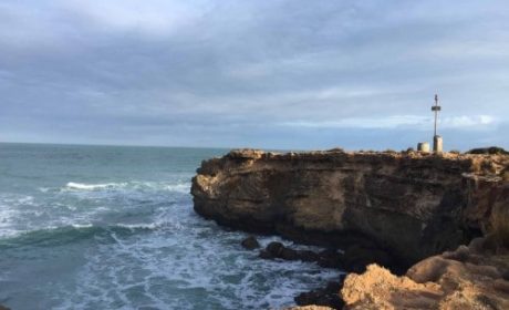
Lookout at The Crags

We find some of the best stops on a road trip are when we take a detour. On our way to Port Fairy in Victoria, we came across a tourist signpost and decided to take a short detour. We discovered The Crags, Port Fairy lookout, at the very start of the famous “Great Ocean Road.” Here we discovered some of the most beautiful scenery the Shipwreck Coast has to offer.

Just 12 kilometers from Port Fairy, the lookout provides spectacular views of the rugged coastline. Rocky limestone outcrops, dating back many thousand years are home to hundreds of bird species. The lookout provides breathtaking scenery of the rugged stone formations that give the “Shipwreck Coast” its’ name.

Natural erosion, farming and tourism over many have had a serious impact on the area so local groups have been undertaking major conservation replanting in recent years to revegetate the area. It is also a preservation area for many items of archaeological and cultural significance, including a number of aboriginal midden sites.
Enjoy the Wildlife at Lady Julia Percy Island
From the lookout you can see Lady Julia Percy Island, six kilometers off the coast. The island is home to one of the world’s largest colony of fur seals and a rookery for fairy penguins. Seal hunting during the 19th century threatened the species which are now protected. While you cannot land on the island, it is possible to take a tour from Port Fairy to view the seals.
Lady Julia Percy island is a major volcanic site. The Island is of cultural significance to the local indigenous people, who were traditionally buried with their heads facing the island.
The beach area below the lookout is a breeding ground for Hooded Plovers, one of Australia’s most threatened bird species as well as numerous other bird life. Watching the rocks, you can see the flurry of birdlife in the sheltered rookeries.
National Trust buildings
Strolling along the main street of Port Fairy and along the riverside, restored bluestone cottages sit side by side with modern holiday homes. More than 50 buildings are national National Trust classified and many have been lovingly restored.
We enjoyed exploring the streets lined with Norfolk Pines, admiring the old seafarers cottages, historic stone churches and old whitewashed buildings. A heritage walking trail takes you past most of the significant buildings, with story boards detailing their history.
Victoria’s oldest pub, the “Caledonian Inn” dating back to 1844 is one such whitewashed relic, the name itself a nod to the area’s original Scottish immigrants. Maintaining its traditional corner position, it still serves a refreshing pint and an excellent counter meal.
Fisherman’s Wharf
While in the area, we enjoyed a stroll with the dogs along the Fisherman’s Wharf, admiring the fishing boats, luxury yachts and the row of old riverside homes, many of which have been restored into guest accommodation. Shady picnic and swimming areas abound, but on a cold, blustery July day, the dogs wanted nothing better than a frolic in the off-leash area.
If you’d like to get out on the water, you can book a charter excursion, whether its for a day’s fishing, whale watching or exploring the Mutton Bird and seal colonies on Lady Julia Percy Island.
Battery Hill
Established back in 1861 as a volunteer coastal fortification, many of the canons are still in place. Concrete bunkers and cartridge recesses surround them in the bluestone fortifications. The flagstaffs previously used to signal passing ships are still standing proudly at the top of the hill today. Climbing to the top gives spectacular panoramic views of the Moyne River and the Southern Ocean at the end of the Shipwreck Coast.

Dating back to 1844, the Caledonian Inn, Port Fairy is Victoria’s oldest licensed hotel. Strolling along the historic streets cape you will find a diverse range of galleries and antique stores where we enjoyed a morning browsing. There’s also no shortage of cafe’s and pubs to enjoy a relaxing coffee or a quick counter meal.
From Port Fairy you can enjoy ocean cruises and sightseeing tours, as well as day trips to surrounding national parks and hiking trails. Many years on, I still found it to be one of the prettiest towns along the Great Ocean Road.
Third Stop: Camperdown
Port Fairy to Camperdown: 1 hour
Besides its pastoral history, Camperdown is also located on the world’s third largest volcanic plain, surrounded by large freshwater lakes. It offers spectacular views, easy walking trails and a great opportunity to enjoy the natural beauty of the area.
We drove to the top of Mt Leura, one of two scoria mounds. Here we had panoramic views across the surrounding dairy farms and the surrounding crater lakes which dot the rural landscape. The landscape looks like a giant patchwork quilt, the crumbling stone fences dividing the paddocks. The lush green irrigated pastures strongly contrast with the barren brown earth and the rock formations.

Scottish immigrant farmers erected drystone walls as a solution to the rabbit problem during the 19th century. The walls are an historic feature of this part of Victoria. Many of them are now heritage protected. You can still see remnants of these walls defining the landscape like a patchwork quilt from the lookout on Mt Leura.
The mounds were formed up to 40,000 years ago as the result of gaseous volcanic eruptions. The two mounts were important landmarks for the local Leehura people. They used them as navigation markers from the plains below as well as lookouts for monitoring the movements of both game and neighboring tribes.
Quarrying up until the 1970’s was threatening to destroy the Mount Sugarloaf scoria cone. This became the subject of a major conservation battle until the National Trust acquired the area in 1972. Local conservation groups, schools and community organizations have been working to bring the area back to pre-European conditions. The groups have undertaken extensive revegetation work.
Lake Bullen Merri
The largest crater lake, Lake Bullen Merri, is located just outside Camperdown. It is a popular destination for camping, fishing, swimming and water skiing. It was totally deserted on a blustery, cold Victorian day when we visited. However, it is easy to imagine how the area would become a haven for summer water sports on a hot January day.
Just over 2 hours from Melbourne, Camperdown is often bypassed as a destination on Great Ocean Road trips. However, it is well worth a stop off to explore the walking trails and the natural history of the crater lakes.
Need some tips for what to do an see in Melbourne? Check out our Active Travel Guide to Melbourne.