Natural Bridges National Monument, located 35 miles west of Blanding, definitely qualifies as a hidden gem in southeast Utah. It’s a fun American Southwest adventure to add to your next road trip. Alan and I are certainly glad that we did!
The national monument offers hiking opportunities to three sandstone land bridges, as well as some of the darkest skies you’ll ever experience for stargazing. But if you’re short on time, the 9-mile scenic drive is a great way to see this Utah park.
Although you might not have heard about Natural Bridges, President Theodore Roosevelt named the area as Utah’s first national monument in 1908 after National Geographic Magazine wrote about the land bridges in a 1904 article.
The bridges have had several names over the years. In 1909, they were given Hopi names of Sipapu, Kachina and Owachomo.
On March 6, 2007, International Dark-Sky Association named Natural Bridges Monument as the first International Dark Sky Park (more here). It’s known for the river of light that’s created when the Milky Way rises over Owachomo Bridge.
Attending a ranger-led stargazing program is a must-do for those camping overnight at Natural Bridges.
Boomer Travel Tip
We always pack our Benchmark Utah Road & Recreational Atlas when exploring this part of the country.
Table of Contents
Driving Natural Bridges National Monument scenic drive loop
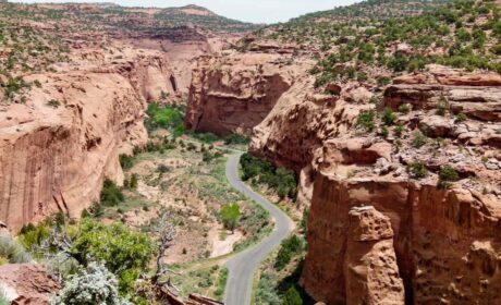
Like Monument Valley Scenic Drive, the one-way, 9-mile scenic loop drive at Natural Bridges National Monument isn’t meant to be rushed. Although it takes about an hour to drive the loop if you hurry, I recommending a slow travel approach.
Take your time to admire the sandstone landscape of White Canyon and to observe the high desert plants of the Colorado plateau. Stop to remember the ancient peoples who admired the same landscape long before your arrival. Allowing enough time for a hike to at least one of the bridges is a wise choice, too.
The loop, also known as Bridge View Drive, is an easy-to-navigate, mostly flat drive with lots of high desert scenery. As I mentioned earlier, it’s one-way so once you begin this Natural Bridges drive, you are committed to completing it.

Stretch your legs at several parking areas with short walks to overlooks of the natural bridges—Sipapu, Kachina and Owachomo. There’s also an overlook for Horse Collar ruin, an ancestral Puebloan site.
Beginning at the Visitor Center, before starting the Natural Bridges scenic drive, introduces visitors to the history and geology of the area. Don’t miss the movie!
Sipapu Bridge

At the first stop, walk the very short trail to the Sipapu overlook. The second largest natural bridge in the United States, is easy to see and photograph from this viewpoint.
A steep trail winds down the canyon to massive Sipapu Bridge—220 feet high with a 268 feet span. My fear of heights kicked in when I learned that climbing down ladders was part of the journey.
Alan and I remained at the top to enjoyed the view from the overlook. But if you’re interested in hiking to Sipapu, plan for 1 to 2 hours round-trip.
Horse Collar Ruin overlook
Next on the Natural Bridges scenic drive tour is Horse Collar Ruin overlook. The unpaved trail leads 0.3 miles to a view of an Anasazi cliff dwelling located across the canyon.
You’ll need binoculars or a camera zoom lens to get a good look. If you’re exploring Natural Bridges by foot on the 5-mile trail that visits all the bridges, you’ll pass by Horse Collar Ruin.
Kachina Bridge

In the middle, both in size and location, Kachina Bridge is the second bridge you’ll see on this drive. But it’s the widest in girth at 44 ft.
To reach the overlook from the parking area, you’ll walk on a steep, paved trail—there are handrails—0.3 miles to the Kachina Bridge overlook. Here, you’ll have a good view of the bridge as it spans Armstrong Canyon, a tributary of White Canyon.
If you’d like to hike down to the bridge, expect a very steep, 1.4 mile round trip hike. Standing underneath Kachina Bridge is one of the rewards, along with checking out the petroglyphs on the side of Kachina. The journey includes negotiating a wooden ladder, as well as rock and wooden stairs plus switchbacks.
Boomer Travel Tip
Check out more of our national park travel ideas.
Owachomo Bridge

An extremely short paved path leads to the Owachomo Bridge overlook. After admiring the bridge, look down to a pool of water known as Zeke’s bathtub.
But don’t think about hiking down for a swim. It’s against park regulations.
Don’t stop here! Thought to be the oldest—and thinnest of the Natural Bridges—Owachomo is accessible on a half-mile round-trip hiking trail. It’s the easiest hike in the national monument.
For someone like me, who has an issue with heights, standing underneath Owachomo Bridge is a treat.

How to get to Natural Bridges National Monument
To say that Natural Bridges National Monument is off-the-beaten-path is an understatement. Located on the Colorado Plateau in southeastern Utah, Natural Bridges is approximately 35 miles west of Blanding.
It’s one of the Utah stops along Trail of the Ancients Scenic Byway.
Natural Bridges is accessible by automobile or bike. The usual route is to drive west on Highway 95 out of Blanding, before turning onto Highway 275 which dead ends at the monument.
To reinforce the idea that this part of the country is isolated, there is no cell service. State Route 95 didn’t even exist until the uranium boom of the 1950’s. And the road wasn’t paved until 1976.
During the early part of this century, visitors rode 3 days on horseback from Blanding to reach the national monument. Now that’s off-the-beaten-path!
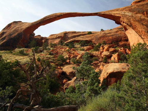
A trip to Natural Bridges National Monument makes a great diversion on a road trip between Moab and Monument Valley. After exploring the many (over 2,000) arches at Arches National Park, you’ll appreciate the intimate feel of Natural Bridges.
Arrive at Natural Bridges, Utah the adventurous way

Of course Alan and I never arrive the easy way. We chose to cut across the Colorado Plateau on Butler Wash Road, a dirt track that parallels Comb Ridge between Highway 163 out of Bluff (our headquarters for exploring this region of Utah) and Highway 95.

Now part of Bears Ears National Monument, the area is filled with prehistoric sites including Anasazi ruins and rock art, if you know where to look. Exploring in more detail is on our boomer to do list for another trip.
Take the exciting route back to Bluff

After completing our drive in Natural Bridges National Monument, there was still enough daylight left for more boomer travel adventure. Once again, we chose the adventurous way back to our lodging in Bluff.
We continued on Highway 95 to State Route 261 that crosses Cedar Mesa. Moki Dugway, a dirt road worthy of a thrill ride travels down from Cedar Mesa and back to Highway 163 and Bluff.
Hold on tight to the steering wheel as your vehicle descends 1,200 ft on 3 miles of switchbacks at 11% grade. This road is not recommended for RV’s.
Boomer Travel Tip
Planning a trip to Utah? Take a look at our Utah Travel Resources.
Before driving down Moki Dugway, turn right for the fantastic view of the San Juan River goosenecks at Muley Point Overlook. On a clear day, you’ll see the spires of Monument Valley silhouetted against the sky.
If there’s time, after descending the steep road, stop at Goose Necks State Park or venture into Valley of the Gods. Another option is to save these two adventures for a second day of exploring during your time in southeastern Utah.
Tips for visiting Natural Bridges National Monument
While Blanding offers the closest accommodations, Alan and I prefer staying in Bluff when exploring southern Utah. For a more upscale experience, our choice is Desert Rose Inn & Cabins. If you enjoy the intimacy of a bed and breakfast, we highly recommend Valley of the Gods Bed and Breakfast.
There is no food available at Natural Bridges so pack a picnic and snacks. Due to high altitude (elevation 6250 ft) and dry, high desert environment, bring lots of water as well as a wide brim hat and sunscreen.
The temperature fluctuates widely in the high desert, sometimes as much as 40 degrees. Summer temperatures can exceed 100 F. with winter lows below 20 F. Monsoons are possible in mid to late summer. Checking the local National Weather Service forecast before starting out is always a good idea.
I recommend April-May or mid-September to October for the best weather experience. You’ll avoid summer’s searing heat. Natural Bridges is open during the winter, with limited services.
Natural Bridges National Monument scenic drive loop is paved, as is Highway 95. Be sure to gas up in Blanding (or Bluff) as fueling opportunities are very limited.
It’s always a good idea to check road conditions at the official Utah Department of Transportation website. Do this before leaving Blanding or Bluff as cell service is extremely sparse.
The 13-site campground, which is open year-round, is located near the Visitor’s Center. It offers basic sites with no hookups, electricity or running water. The spots are filled on a first-come first-serve basis.
You may see a desert cottontail, chipmunk, rock squirrel or other small mammals during your visit. Mule deer are best seen at dawn or dusk. The National Monument is also home to mountain lions, coyote and black bear, but you’ll probably see their tracks rather than the large mammals themselves.
More to see near Natural Bridges National Monument:
Monument Valley is the big draw in this part of southern Utah. Here are some of the lesser known places to see near Natural Bridges.
- Explore Valley of the Gods, a mini Monument Valley
- Drive the Moki Dugway
- Visit Goosenecks State Park
- Raft the San Juan River
Save to Pinterest