Are you planning a South Dakota road trip? Don’t leave Custer State Park and the Badlands out of your itinerary. On her boomer road trip, Vickie Lilo discoverd abundant wildlife sightings, an intriguing landscape plus plenty of Wild West history.
Vickie Lillo writes about her South Dakota itinerary that included Custer State Park, the Black Hills and Badlands National Park. But, first, you need to board a train.
Table of Contents
Riding the 1880 Train: a journey into Wild West history
Chug, chug, chug, the 1880 Train moved along the rails, belching steam into the Black Hills. Destination: Oblivion. Well, not now…in its prime.
Oblivion actually had been a logging camp for mining operations. Today, the Black Hills Central Railroad (website here) runs between Hill City, South Dakota, and its neighbor, Keystone, an hour away.
The steam train ride provides a new generation of folks the chance to relive – and savor – a taste of the Old West. It’s also a chance to memorialize the vital role that rail transportation played in the early years of the United States.
My husband Gustavo and I, along with my in-laws, are along for the ride. Settled back against the black cushions, rimmed on the corners with metal straps that, when clamped into position, rotate the seat to face the opposite direction. Small vintage lamps dangle from wooden beams running down the center aisle.
Originally, this railroad spur of the Black Hills Central Railroad (known locally as the 1880 Train) shared the track with Burlington Northern. In 1957, its new owners restored the bygone-era-style cars, converting the conveyance, long after its heyday had faded, into a passenger train, to ferry tourists between these two former mining towns of the late nineteenth century.
All Aboard the Black Hills Central Railroad

Braying “All Aboard”, the conductor calls out the words that signify the beginning of our journey. Each narrated, one-way route of ten miles lasts an hour.
Clanking past such landmarks as Black Elk Peak. At 7,242-ft, the mountain is not only the state’s highest point, but also the highest elevation between the Rocky Mountains and the French Pyrenees. Formerly Harney Peak, the geology is comprised of the same rose-tinged granite as the South Dakota stone monuments of Mount Rushmore National Memorial and Crazy Horse Memorial.
A stone fire tower, built by the Civilian Conservation Corps (CCC) in 1938, sits astride the summit. Though decommissioned, the fire tower is a welcome sight for hikers attempting the strenuous climb for the panoramic view of five states.
“Ladies and gentlemen,” a commentator warns, “Please don’t hang any arms, legs, or children out the window. No wives, or husbands either. That was yesterday.”
Silly, canned humor, but it has the desired effect. A ripple of laughter courses amongst the guests, prompting the next words of caution.
“Also, no smoking. Since we use 200 gallons recycled motor oil and 2,000 gallons of water, we do enough smoking and steaming for all of us.”
We sink back into our seats, and await the air signal to blow, to shrilly announce the commencement of one more pilgrimage for this oldest continuously-operating touring railroad in the country.
Chugging through the Black Hills of South Dakota
Sure enough, within seconds, the whistle trumpets a succession of two quick bleats, to herald our advancing forward. Actuated by a pull cord (a spring-loaded spindle, of sorts), the locomotive operator is able to give a bit of expression…by volume or pitch…with his tugs on the horn.
Before radio communication came about in the 1960’s, the steam engine’s whistle system was an audible alert network that provided information to railroad employees, both on and off the train, and prevented collisions on the tracks.
As the steam pressure from the boiler forces reciprocating pistons to move back and forth, the main wheels begin to surge along the track. We are underway.
Shuffling along with a steady gait, the steam train scuttles over the railings on the outskirts of town, passing a telephone pole sporting an osprey’s nest. Supposedly, the roosting female is feeding a pair of eaglets, though without my binoculars, my vision is extremely limited. A missed opportunity.
We continue progressing at a 46% grade, one of the steepest in the United States, towards the distant forests of elm, ash, and willow. But mostly, the forests are populated by Ponderosa pines.
Dominating 80% of the surrounding Black Hills, these timber trees, with their juniper needles unable to reflect rays of sunshine, cast an ebony hue on the distant buttes. The loggers called the young arbors, Black-jacks for their blackish-brown bark.
The train rounds the bend and Gustavo quickly snaps a photo of the steam engine following the curve, with wisps of diaphanous vapor pouring from the smokestacks.
Learning the Train Signals
Approaching a crossing, the first of many, the whistle shrieks again.
“You’ll be hearing that about 14 times on this trip,” the lady’s voice advises.
Two long beeps, one short, followed by one more long. The Morse code spells out the letter Q…for Queen.
The signal originated in the United Kingdom. Whenever the Queen’s barge was coming along the river, all other transportation had to cede the way. North America adopted this same practice at its rail crossings.
“Morse Code, for those of you who don’t know, is early texting technology.” More of the canned humor.
The scenic ride passes by open field, faraway modern houses reeking of splendor, and abandoned mining encampments. A Sears Roebuck home, purchased through their catalogue, stands behind a tin windmill at the base of Palmer Gulch.
Today, the domiciles of the new millennium meld with the dwellings of the Old West. Back then, it was the train that was responsible for taking settlers to their homesteads and shuttling miners to their respective camps. After all, the Gold Rush was on in the Old Wild West.
The Black Hills Gold Rush is On
I close my eyes for a second, breathing in the fresh air. My imagination travels back to 1874, when George Armstrong Custer led the 1,000 men of his 7th Cavalry from Ft. Abraham Lincoln in the Dakota Territory on an expedition through the Black Hills.
He was In search of a suitable site for an army fortification. But Custer also wanted to verify the rumors that had circled about for decades that there were valuable resources on the Sioux’s sacred land.
Two miner attachés tagging along with the military commander happened to discover miniscule quantities of gold in French Creek, near present-day Custer, just down the road. News spread like wildfire, especially in light of a dispatch sent via courier to Ft. Laramie, Wyoming, and simultaneously telegraphed to the press.
“There is no doubt as to the existence of various metals throughout the hills…examinations at numerous points confirm and strengthen the fact of the existence of gold in the Black Hills.”
In the blink of an eye, the Gold Rush was in full swing. Also, in the blink of an eye, the 1868 U.S. Treaty of that same Fort Laramie…a guarantee from the Federal government to the Sioux Nation prohibiting white settlement on Indian land…was disregarded.
Prospectors flocked to the southern Black Hills like vultures to carrion, eager to gobble up whatever riches the earth might yield. In droves, the scouts descended on the creek, using their pan-mining techniques to sift through the sediment, mud and stone.
Slim pickins’ mostly. Until they branched out to the northern hills and discovered placer gold deposits at Deadwood Gulch, so named for the dead-and-dying trees that littered its canyon.
Naturally-eroded placer gold…loose pieces of ore mixed in with rock and dirt…always had to have a source. Indeed, on April 9, 1876, brothers Fred and Moses Manuel uncovered a good-sized vein near current-day Lead, South Dakota.
Staking their claim and naming it the Homestake Mine, the brothers sold it the following year to a group of out-of-state investors for $70,000. As it turned out, this was the mother lode deposit that would end up as the most significant gold deposit in American history, supplying 10% of the world’s cache of gold over the next 125 years, to the tune of over $1 billion.
The Return Ride from Keystone to Hill City

I open my eyes once again and the images of scraggly-bearded prospectors with grimed faces from lack of bathing subside. The train sways gently, every now-and-again clanging against the steel pilings.
Going around another curve, the announcer intimates, “If you get a little bit of sand through the open window, no need to give it back. It’s free.”
Sand, it appears, is used to clean the soot from the engines.
Shortly, the train pulls into the station at Keystone. Having opted for the 15-minute stop, instead of the 2-hour sightseeing delay, proves to have been a mistake. Ambling down the quay from our car to Main Street, in itself, takes about six minutes.
Accomplishing a restroom break here, with the other hordes of passengers having the same idea, ends up being completely out of the question. Before we even know it, we’re all back aboard the 1880, in the direction of Hill City.
Enroute, the train swings around the backside of the Mt. Rushmore Mountain carving, and past a creek running parallel to the tracks. We survive a boiler blow-down… an accumulation of debris in the steam engine’s drum… whereby massive water pressure from supplies hauled in the rear wagons is flushed through the boiler, while in motion.
Without standing, Gustavo’s able to photograph a pair of white tail deer and spots wild turkeys. I notice a red-winged blackbird, but not much else.
I’m more concerned with reaching the bathroom at the upcoming station. Within minutes, after refocusing on succumbing to the rhythm of the rails, I’m delighted to see the brightly-painted water tower at the Hill City depot.
Hill City: The heart of the Black Hills
Heart of the Black Hills is a distinction the town of Hill City derived from its proximity to the geographical center of the Black Hills (at 43°56′01″N 103°34′17″W latitude/longitude). Hill City is also surrounded by the region’s tourist destinations.
Inhabited since 7000BC, the Arikara had arrived by 1500AD, followed by other indigenous peoples…the Cheyenne, Crow, Kiowa, and Pawnee Indians. It wasn’t until the 1800s that the Lakota Sioux arrived.
After suffering a loss in Minnesota tribal wars, the Lakota Sioux migrated to the Black Hills. Here, they defeated the Cheyenne, claiming the Black Hills as sacred to the Lakota tribe.
When Custer’s expedition discovered gold just 13 miles south of Hill City, the Black Hills opened to the influx of gold prospectors, miners, and settlers. Known as Hillyo, Hill City became the first settlement in Pennington County and is the oldest city still in existence.
Despite being an older community, Hill City played second fiddle to the close by town of Custer, due to Custer’s designation as the original community of the Gold Rush. When the ore finds became fewer and fewer, finally petering out, miners relocated to the northern Black Hills. Hill City nearly turned into a ghost town.
But Lady Luck returned to this isolated and forsaken mountain range rising out of the Great Plains of North America. In 1883, a malleable and silvery-white metal…tin…was unearthed nearby, and the population rebounded.
Main Street became the headquarters for the Harney Peak Tin Mining, Milling and Manufacturing Company. In its short-lived era of renewed prosperity, Hill City became slightly infamous for its wild and wicked living, with 15 saloons located on the primary drag alone.
“A town with a church on each end and a mile of Hell in between,” someone said.
The tin-age, like the gold rush, eventually waned. But during the 75-year heydey, over $66 million worth of valuables had been mined from the Black Hills.
The mining institutions dried up and blew through these mountains as fast as a tumbleweed stirring in the wind. The industrial railroad took its place, dominating the first half of the emergent century, with tourism and timber taking the lead.
Custer: Another wild west town at the Edge of Custer State Park
Dodging raindrops that have just started to fall, the four of us climb back into our car to set a course for another settlement of the Old West. The town of Custer was born after gold miners had trodden onto the forbidden Oglala Sioux homeland within the protected Great Sioux Reservation.
The miners took every ounce of gold they could carry off, by hand or by wagon. These early mining settlers requested that a 150-ft. wide main avenue through town be designed so that ox teams pulling covered freight-wagons could make U-turns, if the need arose.
Established in 1875, Custer took its name, obviously, from the same Lt. Colonel who had traipsed his entire cavalry unit through the Lakota’s sacred ground. By 1877 (after gold was found), the U.S. government promptly forced the Lakota Sioux to give up most of the Black Hills.
In its heyday, 10,000 folks settled in Custer. When everything went bust, the town dwindled down to a measly 14 locals.
Nearly abandoned completely in 1876, after larger gold strikes in Deadwood Gulch, Custer currently has a couple thousand permanent residents. As a mile-high mountain town sitting on the edge of Custer State Park, it is crisscrossed by miles of backcountry roads and meandering trails left behind by the vestiges of western pioneers, ranchers, and logging crews.
As we grab a bite to eat in this booming, modern-day tourist-town, we are reminded of its motto: Be minutes-not miles from all the great adventures of the surrounding Black Hills.
Custer State Park: where the buffalo roam

Literally “minutes, not miles” along the highway, we approach the entrance to Custer State Park. As the oldest and largest state park in South Dakota, these open plains may just have served as the inspiration for the song, Home on the Range.
In a seemingly-endless expanse of rugged beauty, bison still thunder across the flatlands and feed in the tall grasses. If you arrive in September during the annual buffalo roundup and subsequent auction, you’ll feel the earth tremble from the rumbling of their hooves.
As the ranger at the Visitor Center explains, it all centers around range-forage management. The practice follows the natural scientific study and conservation of the savannahs and prairies, where domestic livestock and wildlife nibble on herbaceous plants and forbs.
“No supplemental food is given to any of the animals, so we have to determine how much to reduce the herd, in order to keep only about 1500 bison, so all have enough to eat throughout the winter. Since all of the animals in the park are grazers…all eat the same grass.”
Scenic drives in Custer State Park

You’ll find three scenic drives at Custer State Park, all masterpieces of engineering. The roads are part of the Peter Norbeck Scenic Byway. To get the most out of your experience, allow plenty of time, drive slowly, and enjoy the views.
Needles Highway is 14 miles of snake-like curves and two narrow tunnels. The route ascends to the uppermost heights of The Needles, eroded granite pillars and spires, perfect for climbers. Highlights of the road include Sylvan Lake and the Needles Eye rock formation.
Iron Mountain Road is a beautiful scenic drive through the best of the Black Hills. The 17-mile scenic route connects Custer State Park with Mt Rushmore and includes three tunnels. The road threads through one-lane, rock-walled tunnels and over helix-shaped bridges…called pigtails…that loop over their own road as they climb the steep terrain.
19-mile Wildlife Loop Road winds through prime locations for showcasing its 71,000 acres of plains rife with bison. Be prepared for bison traffic jams and abundant wildlife sightings that might include deer, elk, big horn sheep and more.
Finding the bison and their babies
Glancing at a brochure as we ease along our route, I notice the constant entreaties, “Get caught in a buffalo jam.” With Custer State Park being the proud refuge of the 2nd largest public, free-roaming herd in the U.S., I’m proud to say, we inevitably DO find ourselves in the middle of just such a jam.
In every direction, we see wall-to-wall bison. As warm weather approaches, a gargantuan male rollis in a shallow depression…a wallow…attempting to shed the loose patches of hair from its shaggy, dark-brown winter coat.
This dirt-bath also aids in repelling pesky ticks, fleas, and biting flies. Frisky springtime babies, recently born, cavort through the sedges of the herd. Nicknamed cinnamons for their light, orangish-brown fur, the calves frolic in the grasses or stand close to their mothers, suckling on a teat.
Though Interchangeably called buffalo, from the French ‘le boeuf’…the word for beef…Custer’s nomadic bison are actually larger than the domesticated, nearly-hairless species of Africa and Asia. They have a noticeable shoulder hump of pure muscle and a herculean head.
Unlike their counterparts, the water buffalo from India and the Asian continent, their horns are smaller and fail to arc backwards. Over 30 million of these majestic grazers once roamed the Great Plains of North America.
Editor’s Note: By the end of the 1800s, less than 1,000 bison still survived. Their near extinction has been blamed on white hunters (who certainly shot their share of bison), however here is an alternative historical opinion relating to the bison’s eradication due to disease and another one.
Learning about wildlife at the Custer State Park Visitor Center
Exhibits at the Visitor Center…a must-see attraction which sits at the beginning of the Wildlife Loop Road…offer a wealth of information about these two-ton mammals. Their hides, as well as the skins of all the other park foragers, hang in size-order along a side wall. They are surrounded by taxidermized carcasses of mountain lions and an eagle, all dead by natural causes.
An interactive display entitled How Close is Too Close? instructs park visitors about proper behavior around the bison. Visitors encounter a series of footprints, spaced at varying intervals away from the photo of a 2,500-lb. male. When guests stand on the footprint, they hear the reaction of the bison as they are approaching it.
At 150 yards, there is no reaction, only the sounds of munching as the bull continues to eat. At 75-150 yards, the bison will grunt at you. And at less than 75 yards, an unsafe distance, the bison paws at the ground and begins to snort in a danger signal. Bison have been known to kick at passenger cars, if agitated.
Getting caught in a buffalo jam

But I digress. Getting back to the buffalo jam, our KIA sidles alongside a female bison, ruminating on wildflowers near the edge of the pavement. Her wayward calf darts across the road, directly in front of our car.
Apparently hesitant to have left the protective sanctity of its mother’s side, the two-month-old newborn races back across, with a sense of unease and urgency. Mama bison is not happy, to say the least.
The air becomes overwrought with tension. She snuffles a bit and lets out a low bellow, dispelling both snot and a bit of spittle into the grass. In mere seconds, other cinnamons and their mothers begin to cluster around the distressed female.
For moral support? For strength in numbers? Or just plain brute strength? We’ll never know.
Thankfully, the fast-forming huddle of bison moms, though hindering our further progress on the road, scamper at a frenzied pace to the opposite field, without shooting another glance in our direction.
Gustavo quickly pulls ahead. Perilous confrontation avoided, we all breathe a sigh of relief.
The road continues past the pines, some recently cut and stacked in neat piles, with views of rolling hills and outlying creek valleys. A black-backed woodpecker, ink-colored with a perceptible white stripe across its face, is boring its beak into a burnt-out tree trunk, more than likely in search of beetle larvae.
We meet a profusion of other critters: a trio of pronghorns, napping in the reeds.
“Look for movement in the grass,” I instruct my father-in-law Eduardo, trying to wrestle with the field-glasses from the front seat.
Near the lake, a common magpie glides over the cattails. For Gustavo and I, the birders in the party, it means another never-before-seen specimen to mark off of our life list.
A red-winged blackbird pokes its head out of a nesting box. A small herd of exactly one dozen bison are browsing, while swishing at flies with their tails, and paying us not the slightest never-mind.
Prairie dogs, a keystone species that creates habitats benefiting another 100 parkland animals, pop up everywhere, from their makeshift burrows. A sally of sand spews from the ground before you ever see these social rodents which communicate through a variety of barks.
Squeak, squeak, a playful pup yanks on its mother’s tail. Meantime, a sibling is trying to nuzzle in to nurse.
Nothing Like a arty of panhandling jackasses

Then, there’s Custer State Park’s infamous begging burros to cause another traffic gridlock. The burros beg, slowly maneuvering from car window to car window, nosing their heads inside the automobiles in hope of a snack.
Signs advising, “Do not feed the animals” are visibly ignored as visitors hand apples, carrots, etc. to the wanton donkeys. We become distinctly aware that they will turn their noses up at lettuce leaves. (Editor’s note: Feeding wildlife in national parks is prohibited.)
Introduced in the 1920’s, today’s long-eared park ambassadors are actually descended from a herd of feral burros intended for pack tours, to give trail rides up to Harney Peak. I stroke the velveteen muzzle as a stray moseys to my side of the vehicle, and assure my mother-in-law Isidra (Isi for short) that it’s not carrying any diseases.
Moving on, we spot a white-tailed doe pausing to sip from a brook stream as we head towards the exit. She turns to look back at us, before disappearing into the glade.
We are never afforded the luck of seeing a coyote, mountain goat, bighorn sheep, or elk. I was hoping to sight a harem of yellow-bellied marmots. Any ground-squirrel with a nickname of ‘whistle-pig’…that, I gotta see. Supposedly, the little rock chucks whistle when they spy a predator.
I get a last glance at a solitary buffalo, staring right into my eyes, it seems, as our vehicle pulls out of the park. Sorry there isn’t time or exuberance for hiking the 14 scenic trails, off-roading on ATVs/UTVs, or fat-tire biking.
Camping, fishing in the river, and horseback riding near the Blue Bell picnic area are also available to Custer State Park visitors. Still, we’re content with having seen so much wildlife.
Wall Drug Store: home to five-cent coffee and free ice-water

Wall Drug Store (website here) is responsible for putting the western South Dakota town of Wall on the map. You’re definitely ready for a visit after the too-many-to-count, never-monotonous billboards that stretch along the interstate, advertising free ice water and nickel cups of coffee.
In the midst of the Great Depression, Ted Hustead and his wife Dorothy opened their drugstore. They were happy to service the 326 impoverished folks, mostly down-on-their-luck farmers, who called this stretch of prairie home. With a little initiative, and the promise of ice-cold refreshment on a hot day, at zero cost, the drug emporium also pulled in vacationers on their way to Mt. Rushmore.
Wall Drug, 2021-style, entices almost 20,000 clients on any given summer afternoon. They come for the café, a shopping mall for western wear (genuine right down to the bright-red long-johns with a convenience flap across the buttocks), a paleontology store with replicas of Jurassic-Age creatures, plus a souvenir repository big as Texas (perhaps an exaggeration).
Having guzzled several cupfuls of 5¢ coffee, the family and I pile into the KIA, clutching a half-dozen of the scrumptious, but very pricey, donuts the drugstore is famous for. One last farewell to the 60-ft., bright-green T-Rex dinosaur out by the road, and we set a course for our last stop, Badlands National Park. A spectacular place of surreal beauty.
Badlands National Park: the Lakota Sioux call it makosche shicha

Sculpted 38 million years ago by the whimsy of water and wind from sediments rich in fossils, the Badlands are a stark, landscape, avoided by early pioneers. French fur traders cursed it – les mauvaises terres à traverser (bad grounds to cross). And The Lakota Sioux tribe had bombasted it as makosche shicha, “bad land.”
The Badlands earliest inhabitants, 11,000 years in the past, were mammoth hunters. Nomadic tribes…the Arikara… came later, their very existence centered around the pursuit of bison.
When the Lakota arrived, having adopted the use of horses from the Spanish, they thrived in the region for a century. Then French fur trappers, soldiers, miners, cattle farmers, and homesteaders, descended upon their homeland en masse.
Skirmishes raged, one fracas after another, until the 1890 Indian massacre at Wounded Knee when the Sioux were finally driven back, and confined to reservations. The domestication of cattle quickly replaced the hunting of bison, prairies were taken over by planted fields of wheat, and equine transportation gave over to gas-powered motor cars.
The Lakota, however, still remained on their reservation. So, in 1976, the National Park Service (NPS) and Oglala Sioux Tribe partnered in managing the Badlands National Park (website here).
A Badlands geology lesson: eroding buttes and infinite grasslands

Badlands National Park is a geologist’s dream. It’s home to 244,000 acres of eroded buttes and pinnacles, interspersed by some 64,000 acres of mixed-grass prairie. Containing noteworthy fossil beds, the layered amber-and-red soil rises into sunbaked peaks and spires, which cast strange shadows across the land.
As the summer weather brings on the irreverent heat, we begin to see the surge of wildflowers, mingled amongst the nearly 60 species of grass. Pastures of big bluestem and prairie cordgrass fuse with the shorter stalks of blue grama and slightly-curly buffalo-grass.
Narrow-leaf yucca plants burgeon across the range with fibrous green leaves tapering into spines. They are sharp enough for use as primitive needles. I can only ponder the park’s splendor during the winter months, when Mother Nature’s frosty breath, blowing in from the north, swirls across the Badlands’ snow-dusted spires.
Famed architect Frank Lloyd Wright, dictated in his journal, “I’ve been about the world a lot, and pretty much over our own country, but I was totally unprepared for the revelation called the Dakota Bad Lands…What I saw gave me an indescribable sense of mysterious elsewhere – a distant architecture, ethereal…an endless supernatural world more spiritual than earth but created out of it.”
Wildlife in the Badlands

To better view the unusual rock formations, we opt for the initial overlook, accessed by Sage Creek Rim Road. A sign, and the park brochure indicate that bison supposedly roam here, alongside deer, rattlesnakes and bighorn sheep.
I personally can do without the venomous snakes. Or any snakes, for that matter.
We do see the grazing buffalo herds in the northern sector. Many are sprawled in the weeds…clumps of fur mantled across their backsides dangle in unconforming patches, as their heavy fleece continues to molt.
An exceptionally large bison chews his cud. A second rolls wildly in a small tract of dirt, legs flailing in the air, trying to detach that annoying wool which will soon be replaced by a less cumbersome, coat.
We see a pronghorn, that fleet-footed American antelope that loves chasing the Badlands’ coyotes. The gravel road begins to hug the drop-off that separates the grasslands from the other-worldly terrain below.
Ahead of us, a road grader is stirring up the rubble, showering our car with whorls of dust. Once the two-car traffic jam passes, we push past the heavy-equipment, creating our own twister of grit.
Our group is on the look-out for black-footed ferrets, considered extinct in 1979, but amazingly found a couple years later in the neighboring state of Wyoming. After multiple breeding facilities were established, the ferret population multiplied,
In 1994, 36 of the mammals were released back into the Badlands National Park to, once again, establish their foothold on the prairies. However, our chances of seeing these adorable-faced, white-black-and-grey cousins to the weasel are slim to none. Black-footed ferret are nocturnal, preferring to live their lives in darkness, under the cloak of night.
Furry-animal colonies at Roberts Prairie Dog Town
After the turn-around on this rim road, we return to a site we’d accidentally missed on the way in, Roberts Prairie Dog Town (website here). It’s a must see in the Sage Creek portion of the Badlands, housing one of the largest colonies of black-tailed prairie dogs.
Gustavo and I jump out of the car, leaving my in-laws inside with the binoculars. It is super-windy; the tall grasses and sedges along the roadside are blustering, and I debate on whether or not to grab my scarf.
Whitish, circular mounds dot the plateau. Prairie dogs are literally scattered everywhere: digging ferociously, springing forth like jack-in-the-boxes from tons of tiny burrows, or standing on their back legs as if on sentry duty.
A scuffle ensues and a wounded male slinks away from the female, probably protecting an unseen litter of pups. Bleeding…pitifully squeaking. It breaks my heart.
But this is no time for undue sentiment. There’s unbridled cuteness nearby.
A trio of mischievous pups tease their mum, darting back and forth through her legs. In the distance, an eagle soars high above a profusion of cacti. Roberts Prairie Dog Town is an all-you-can-eat buffet for the raptor.
We are content to appreciate the Badlands from our car… my father-in-law can’t do any real hiking…but for those with the notion, trekking the National Park would be spectacular. We are just hoping to capture a remnant of the magic hour, best experienced early or late in the day when the subtle shades of the buttes deepen into crimson, yellow, and tan.
Waving good-bye to South Dakota’s Wild West

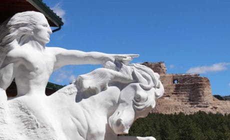
As our vehicle merges back onto the highway in the direction of Nebraska and home, I know that vacation is over. We’ve toured both memorials, Crazy Horse and Mt. Rushmore, and delighted in the hospitable Black Hills and the austere Badlands.
One last time, I imagine I’m back on that 1880 locomotive, bound for Oblivion, along with the other miners. Watching the rolling hills trundle by, swaying to-and-fro with the endless motion of the train ploughing along the tracks. It’s time to wave good-bye to the Old West.
Funny, though, in my mind’s eye, I can still see those early claim-jumpers furtively working the streams panning for those oh-so-elusive nuggets of gold. A few returned home laden with pockets full of gold; most departed nearly penniless, with little to show for their months, even years, of efforts.
I can clearly see those men, dressed in tattered clothes, submerging their riffled, ebony pans in the French Creek, their labor fueled by lust and avarice for gold. Twirling…endlessly rotating the creek water inside their tins…hoping beyond all hope for a glint of gold to have settled in the bottom of the tray when all the excess liquid had drained away.
It was this fever that drove thousands of men, in the first place, to the Black Hills, to those seedy towns of the Old West, more than a century ago.